|
| |
 Playden in East Sussex is about 1 mile north of Rye on the A268. In earlier times
the sea, which is now about 2 miles away came to the bottom of the
hill. The main occupation of the local people was fishing. The fish
were salted, and then laid on the roadside banks to dry. At this
time Playden was known by the alternative name of Saltcote(see below). Playden in East Sussex is about 1 mile north of Rye on the A268. In earlier times
the sea, which is now about 2 miles away came to the bottom of the
hill. The main occupation of the local people was fishing. The fish
were salted, and then laid on the roadside banks to dry. At this
time Playden was known by the alternative name of Saltcote(see below).
Playden seems to have been under Roman occupation as there is evidence of
a Roman villa on the hill, and the track to Saltcote was called Saltcote Street .
In the Domesday Book , it the village is called Plaidenham. With its
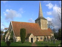
tall, wooden shingled spire, St Michaels Church was built about a
century later stands off the main road. It was built around 1190
and has not been altered much since the Middle Ages.
During the 1400's the Playden fishermen had a bustling fish market, but after
1493 the evidence of the fishmarket vanished probably due to the Rye fishermen
looking on the Playden market as a threat to their income.
In the church there is a massive wooden ladder that leads up to the belfrey, which
has been dated from 1686. It cannot be climbed as it is very worm eaten.
On the floor of the north aisle is a black stone slab. It features a
carving of two casks and a crossed matchstick and fork. It commemorates
a Flemish brewer, Cornelis Roetmans who was buried here in 1530. The
carvings were originally inlaid with brass.
Below the north tower arch there is a magnificent 14th century wooden
screen, and above the chancel arch are the Royal Arms of George III .
During the Second World War , Playden was fitted with dragons teeth tank traps to prevent
the Germans attacking the Southern Command HQ which was located at Saltcote Place , the same
type of tank traps can be seen surrounding Cripps Corner which was another HQ.
(Many thanks to Neil Davenport for the following corrections)
The area you have as Playden is actually a combination of Rye Foreign
(the area to the west of the A268) and Playden (the area to the east
of the A268 down onto the marsh around the north of East Guildeford.
This is a well established error locally, the County Council having
many years ago put the Playden sign at the top of Rye Hill in
Rye Foreign with the result that the residents of Leasom Lane
(running west from the A268 immediately north of the Rye Memorial
Care Centre) all claim a postal address of Playden and had to be
removed from the electoral roll some years ago as they were found
to be claiming to be in Playden.
Also, Playden has never had Saltcote as an alternative name,
that was the name of the long disappeared hamlet at the bottom of
what is now New England Lane, formerly known as Saltcote Street.
Playden has always been the parochial district which included
Houghton Green as well as Saltcote.
In the Doomsday Book, it is called Plaidenham. |
|
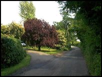 Playden in East Sussex church is very old and pretty to visit. Playden in East Sussex church is very old and pretty to visit.
The best views are from the back road down to the military canal,
where you can see across the Romney Marsh . |
|
 Playden in East Sussex has no village centre as such, and its main services
are in Rye about 1 mile away to the south. The nearest
supermarket is in Peasmarsh about 3 miles to the west on
the Hawkhurst road. Playden in East Sussex has no village centre as such, and its main services
are in Rye about 1 mile away to the south. The nearest
supermarket is in Peasmarsh about 3 miles to the west on
the Hawkhurst road.
The nearest trains go from Rye hourly to Ashford and Hastings. |
|
| Playden is shown as the red symbol on the map. |
|
|
Nearby Villages
(click on symbol to see the village page) |
| Village= | |
Town= | |
Recorded in Domesday= |  |
| |
|
|
Beckley |
(Alfred the Great and Guns !) | | 4.83 miles |
|
|
Brede |
(Edward I inspects the Channel Fleet) | | 7.08 miles |
|
|
Brenzett |
(St Eanswyth a saxon princess) | | 5.29 miles |
|
|
Broad Oak Brede |
(On the Crossroads) | | 6.78 miles |
|
|
Brookland |
(13th century wooden spire) | | 4.22 miles |
|
|
Broomhill |
(Swept away by the Storm) | | 4.09 miles |
|
|
Camber |
(Sands and Holidays) | | 3.29 miles |
|
|
East Guldeford |
(Barn-like Church) | | 1.04 miles |
|
|
Fairfield |
(The Isolated Church) | | 3.10 miles |
|
|
Icklesham |
(Paul McCartney's Recording Studio) | | 5.13 miles |
|
|
Iden |
(Sheriff of Kent and Jack Cade) | | 1.01 miles |
|
|
Ivychurch |
(The burial ground on the Island) | | 6.72 miles |
|
|
Newenden |
(Alfred the Great's Fort) | | 6.54 miles |
|
|
Northiam |
(Prime Ministers D Day inspection) | | 6.65 miles |
|
|
Old Romney |
(Sheep and Wool Smuggling) | | 6.56 miles |
|
|
Old Winchelsea |
(Abandoned after the Great Storm) | | 3.56 miles |
|
|
Peasmarsh |
(Black Death moves village) | | 3.08 miles |
|
|
Rye |
(On the Island) | | 1.71 miles |
|
|
Rye Harbour |
(Nature Reserve and unspoilt beaches) | | 2.52 miles |
|
|
Snargate |
(Sluice Gates made by Royal Order) | | 5.23 miles |
|
|
Stone in Oxney |
(Roman stone altar) | | 3.12 miles |
|
|
Udimore |
(Angels move the Church) | | 4.82 miles |
|
|
Winchelsea |
(Inland Cinque Port !!) | | 3.76 miles |
|
|
Winchelsea Beach |
(Holidaymakers and Henry VIIIs Fort) | | 4.10 miles |
|
|
Wittersham |
(Park your Airship here ?) | | 3.26 miles |
|
|


